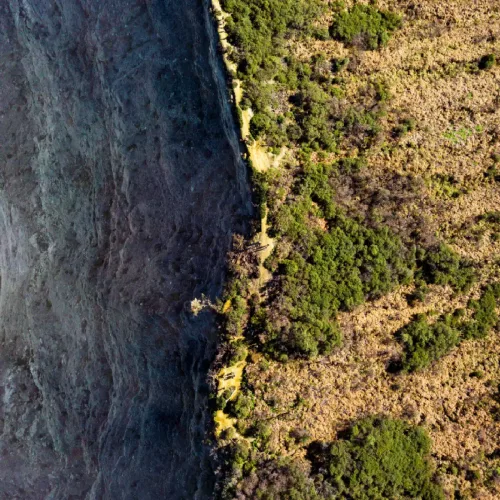
On August 10, 2020, a wall of wind tore across the American Midwest with almost no warning. In just 14 hours, it traveled 770 miles from South Dakota to Ohio, flattened millions of acres of corn and soybeans, and produced gusts as high as 140 mph in Cedar Rapids, Iowa. Many residents assumed a tornado had hit them. It hadn’t. What struck the Midwest that day was a derecho — and by the time it dissipated, it had caused an estimated $11 billion in damage, the costliest thunderstorm event in U.S. history.
If you’ve never heard “derecho” before a headline like that, you’re not alone. Despite being one of the most destructive thunderstorm systems on Earth, derechos remain widely misunderstood. People often mistake them for tornadoes because the damage looks similar — snapped trees, flattened crops, torn-off roofs — but the physics couldn’t be more different. Tornadoes rotate. Derechos don’t. They travel in a straight line, sometimes for hundreds of miles, hitting entire regions with hurricane-force winds all at once rather than along a narrow, twisting path.
In this guide, you’ll learn exactly what a derecho is and how it forms step by step. You will find out why it’s so destructive. You’ll also compare it to tornadoes and hurricanes. Learn how to stay safe when one is bearing down on your area.
What Is a Derecho?
A derecho is a long-lived, widespread windstorm produced by a fast-moving band of severe thunderstorms. It delivers destructive straight-line winds that can stretch for hundreds of miles.
Scientific Definition
Meteorologists define a derecho as a family of downburst clusters linked to a mesoscale convective system (MCS) that produces a continuous or nearly continuous swath of damaging winds. Standard criteria require wind gusts of at least 58 mph (50 knots) along a path of roughly 240–400 miles or more, lasting at least six hours in many definitions. Recent physically based definitions emphasize radar features such as bow echoes and damage paths at least 60 miles wide and 400 miles long.
Why Is It Called a “Derecho”?
The word “derecho” comes from Spanish and means “straight” or “direct.” In the 1880s, Iowa professor Gustavus Hinrichs studied severe wind damage and noticed that many storms produced straight-line destruction rather than the swirling patterns of tornadoes. He proposed the term “derecho” to distinguish these events from tornadoes (from the Spanish word for “turned”). The name stuck and is now used worldwide by meteorologists.
What Conditions Are Needed for a Derecho to Form?
Derechos don’t appear out of nowhere. They need a specific combination of atmospheric ingredients working together, usually during the warm months when the atmosphere holds the most energy.
1. Warm, Moist Air
Derechos typically form when a deep layer of warm, humid air sits near the surface. This moisture fuels the storm — as it rises and condenses into clouds, it releases latent heat that powers the updrafts.
2. Atmospheric Instability
Instability describes how eager warm air is to keep rising once it starts. When the atmosphere is highly unstable — measured using CAPE, or Convective Available Potential Energy — thunderstorms can grow explosively tall and strong.
3. Wind Shear
Wind shear is the change in wind speed and direction with height. Moderate to strong shear helps organize individual thunderstorms into a coordinated, self-sustaining line rather than a cluster of short-lived cells — essential for a system to survive long enough to become a derecho.
4. Strong Thunderstorms
Individual thunderstorms need to be intense enough to generate powerful downdrafts — columns of sinking air that crash into the ground and spread outward. These outflow winds are the direct source of a derecho’s damage.
5. Formation of a Mesoscale Convective System (MCS)
When these ingredients align, individual thunderstorms merge into a mesoscale convective system: a large, organized cluster or line of storms spanning tens to hundreds of miles. Most derechos develop from a specific type of MCS known as a bow echo.
How Does a Derecho Form?
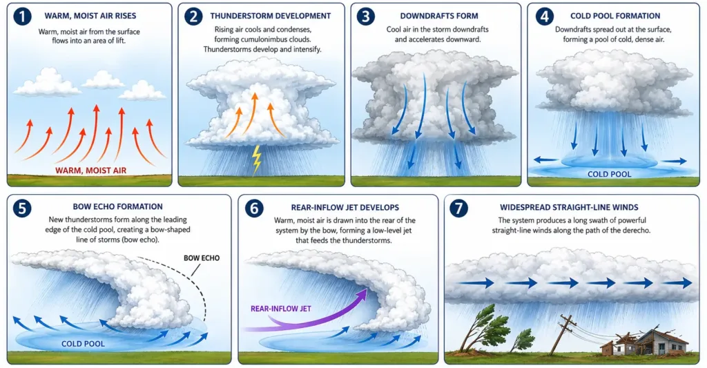
Understanding a derecho’s life cycle makes the whole phenomenon much less mysterious. Here’s how one typically develops, from the first rising air parcel to hundreds of miles of wind damage.
Stage 1: Warm Air Begins Rising
The process starts when surface heating or an approaching disturbance forces warm, moist air upward. As it rises, it cools and condenses into towering cumulus clouds.
Stage 2: Thunderstorms Develop
Individual thunderstorms form and organize, often triggered along a front, dryline, or outflow boundary. In a favorable environment with strong instability and shear, they grow quickly.
Stage 3: Downdrafts Strengthen
Inside mature thunderstorms, precipitation drags cool air downward, creating powerful downdrafts. As these reach the surface, they spread out in all directions — the beginning of damaging straight-line winds.
Stage 4: Cold Pool Forms
Merging downdrafts create a pool of cool, dense air at the surface. This cold pool acts like a wedge, plowing under the warm air ahead of it and forcing new thunderstorm development along the leading edge.
Stage 5: Bow Echo Appears
As the cold pool strengthens and the line accelerates, radar reflectivity often takes on a distinctive bowed shape — a bow echo — because the center of the line, pushed by the strongest downdrafts, moves faster than the flanks.
Stage 6: Rear-Inflow Jet Accelerates Winds
Behind the bow echo, a rear-inflow jet develops: air racing toward the leading edge at altitude, then descending toward the surface. When it reaches the ground, it dramatically boosts wind speeds, often producing the storm’s most extreme gusts.
Stage 7: Long-Lived Straight-Line Wind Event
If the system keeps regenerating storms along its leading edge while sustaining its cold pool and rear-inflow jet, it can keep damaging winds for hours across hundreds of miles, officially becoming a derecho.
What Makes Derechos So Destructive?
Straight-Line Winds
Because derecho winds move in one general direction rather than rotating, they strike everything in their path with similar force at roughly the same time, creating widespread, simultaneous damage rather than the localized destruction typical of a tornado.
Wind Speeds
Derecho winds regularly reach 60 to 100 mph, and the strongest events — like the 2020 Midwest derecho — can exceed 140 mph, rivaling a major hurricane.
Wide Damage Path
A derecho’s damage swath must be at least 60 miles wide in places and extend more than 400 miles in length. The 2020 storm affected a footprint larger than 90,000 square miles.
Long Duration
Derechos can remain active for 6 to 14 hours or more, sustaining damaging winds continuously as the system races across state lines, often faster than residents can prepare.
Flying Debris
Sustained straight-line winds turn ordinary objects — branches, patio furniture, signage — into dangerous projectiles, capable of injuring people far from the storm’s core.
Infrastructure Damage
Derechos are notorious for widespread power outages. The 2020 storm knocked out electricity to more than a million customers, some for over two weeks, while devastating grain bins and transmission towers.
Characteristics of a Derecho
| Characteristic | Typical Range |
|---|---|
| Wind speed | 58–100+ mph (gusts can exceed 140 mph in extreme cases) |
| Storm length (track) | 400+ miles (some exceed 700–800 miles) |
| Width of damage swath | 60+ miles in places |
| Lifespan | 6–14+ hours |
| Rainfall | Heavy, often accompanied by large hail |
| Lightning | Frequent, embedded within the thunderstorm line |
| Geographic extent | Can affect multiple states or countries in a single event |
Derecho vs Tornado vs Hurricane vs Downburst
These four phenomena are frequently confused because they can all produce severe wind damage, but their formation, structure, and behavior are fundamentally different.
| Feature | Derecho | Tornado | Hurricane | Downburst |
|---|---|---|---|---|
| Formation | Organized line of thunderstorms (MCS/bow echo) | Rotating supercell thunderstorm | Tropical ocean heat and moisture | Single thunderstorm downdraft |
| Wind direction | Straight-line, one direction | Rotational (spinning) | Rotational, spiraling inward | Straight-line, radiating outward |
| Wind speed | 58–140+ mph | Up to 300 mph (violent tornadoes) | 74–200+ mph | 40–150+ mph |
| Size | Hundreds of miles long, tens of miles wide | Typically a few hundred yards to 2 miles wide | Hundreds of miles in diameter | A few miles wide |
| Duration | Hours (6–14+) | Minutes | Days | Minutes |
| Damage pattern | Widespread, continuous swath | Narrow, concentrated path | Very widespread, includes storm surge | Localized, sometimes starburst pattern |
| Predictability | Moderate; forecast hours ahead via MCS tracking | Low; short lead times (minutes) | High; tracked days in advance | Low; forms suddenly within a storm |
| Typical season | Late spring through summer | Spring through early summer (peak) | Late summer through fall | Warm season, any severe thunderstorm |
Types of Derechos
Not all derechos look or behave the same way. Meteorologists generally classify them into three structural types.
1. Progressive Derecho
A progressive derecho is a relatively narrow, fast-moving line of storms that races along a single, generally straight path, often associated with a bow echo. This is the classic derecho structure, and it’s what produced both the 2012 and 2020 events. These systems tend to move quickly — sometimes 50 to 60 mph — which is part of what makes them so dangerous; there’s little time to prepare once the threat becomes clear.
2. Serial Derecho
A serial derecho consists of multiple bow echoes embedded within a much larger squall line, typically linked to a strong low-pressure system and a well-defined cold front. These events tend to be wider and are more common during the cooler months, spring and fall, when large-scale storm systems are more active.
3. Hybrid Derecho
As the name suggests, a hybrid derecho blends features of both types — starting with characteristics of a serial event before consolidating into a more progressive, bow-echo-dominated structure (or vice versa) as it evolves. These storms can be particularly difficult to forecast because their behavior changes over the course of the event.
How Meteorologists Detect and Forecast Derechos
Doppler Radar
Doppler radar is the primary tool for detecting an active derecho, revealing the classic bow-shaped signature of the storm line along with rear-inflow jets and rotating segments that could spawn embedded tornadoes.
Bow Echo Signatures
Forecasters watch specifically for the “bowing” shape on radar, along with a rear-inflow notch — a gap in reflectivity indicating a strong jet of air descending toward the surface, often preceding the most intense gusts.
Weather Satellites
Satellite imagery helps meteorologists track the broader environment: the development of the parent thunderstorm cluster, the movement of the associated front, and the system’s overall organization before it matures.
Numerical Weather Prediction Models
High-resolution computer models simulate atmospheric conditions — instability, shear, moisture — hours to days in advance, allowing the Storm Prediction Center to flag a heightened risk of an MCS capable of producing derecho-level winds.
AI and Machine Learning in Forecasting
Meteorologists are increasingly experimenting with machine learning tools trained on historical radar and model data to better predict when a line of storms will organize into a bow echo, an evolving field that shows promise for improving lead times.
Famous Derecho Events in History
2012 North American Derecho
On June 29, 2012, a progressive derecho tore across roughly 800 miles from Iowa to the mid-Atlantic coast in about 12 hours. Wind gusts reached 91 mph in Fort Wayne, Indiana, and over 80 mph near Washington, D.C. The storm killed 22 people, caused around $2.9 billion in damage, and knocked out power to more than 4 million households during a punishing summer heat wave.
Lesson learned: It exposed how vulnerable urban power grids are to a single fast-moving storm, pushing utilities to rethink outage response planning for wind events, not just hurricanes.
2020 Midwest Derecho
The August 10, 2020 derecho remains the benchmark for how destructive these storms can be. Traveling 770 miles in about 14 hours, it produced a measured gust of 126 mph in Atkins, Iowa, and an estimated 140 mph gust in Cedar Rapids — winds equivalent to a strong hurricane. It damaged an area larger than 90,000 square miles, affected more than 20 million people, destroyed an estimated 850,000 acres of Iowa cropland, and caused roughly $11 billion in damage, making it the costliest thunderstorm event in U.S. history.
Lesson learned: Because it arrived with a relatively low severe-weather risk forecast the day before, it became a major case study in improving same-day forecasting for these fast-developing systems.
European Derechos
Europe experiences derechos too, though the term is less commonly used there. The most notable recent example struck on August 18, 2022, when a violent derecho formed near the Balearic Islands and raced more than 1,000 km northeast across Corsica, northern Italy, Slovenia, Austria, and the southern Czech Republic in about 12 hours. Wind gusts reached 224 km/h (139 mph) in Corsica, and the storm killed 12 people and injured more than 100. Researchers noted that an unusually intense Mediterranean marine heatwave likely contributed to its severity.
Lesson learned: It showed that derechos are not a uniquely American phenomenon, prompting European agencies to improve public communication around a hazard less familiar to their audiences than tornadoes or hurricanes.
Canadian Derecho Events
Southern Ontario and Quebec regularly see derecho-type windstorms each summer, often as extensions of systems affecting the U.S. Midwest and Great Lakes region, producing tree damage, power outages, and occasional embedded tornadoes.
Can Derechos Occur Outside the United States?
Yes. While the term originated in the U.S. Midwest and the country experiences the highest frequency of derechos globally — largely due to its unique combination of Gulf moisture, jet stream dynamics, and vast, flat terrain — derechos are a global phenomenon.
- Canada: Southern Ontario, Quebec, and the Prairies see derecho-type events most summers, often linked to systems tracking out of the U.S. Midwest.
- Europe: France, Germany, Poland, Italy, and the Czech Republic have documented derechos, with research suggesting France alone sees several qualifying events per decade.
- South America: Argentina and southern Brazil’s Pampas region experience severe convective windstorms with derecho-like characteristics, driven by similar instability and low-level jet dynamics.
- Australia: Long-lived squall lines capable of widespread wind damage have been documented, though formal derecho classification remains less developed than in North America.
- Asia: Parts of northern India and China have recorded severe windstorm events consistent with derecho criteria, though long-term study is still limited.
How to Stay Safe During a Derecho
Before a Derecho
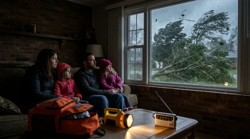
- Sign up for local weather alerts and keep a NOAA weather radio or alert app handy.
- Know the difference between a Severe Thunderstorm Watch (conditions are favorable) and a Warning (a storm is imminent).
- Secure loose outdoor items — furniture, grills, trampolines — that could become projectiles.
- Identify a safe, windowless room on the lowest floor of your home in advance.
- Stock an emergency kit with water, food, flashlights, batteries, and a portable charger, since extended power outages are common.
During a Derecho
- Move indoors immediately and stay away from windows, which can shatter under wind pressure.
- If driving, pull over safely away from trees and power lines, and stay in the vehicle if you can’t reach shelter.
- Avoid corded electronics during active lightning, which is often embedded throughout the storm.
- Do not go outside to “check on” the storm — flying debris causes most derecho-related injuries.
After a Derecho
- Stay clear of downed power lines and assume all of them are live.
- Watch for structural damage before re-entering buildings, and beware of weakened trees that could fall later.
- Check on elderly or vulnerable neighbors, since extended outages pose real risks in extreme heat.
- Document damage with photos for insurance once it’s safe to do so.
Frequently Asked Questions
A derecho produces straight-line winds from a line of thunderstorms; a tornado produces rotating winds from a single spinning cell. Derechos also affect far larger areas over longer periods.
Research is still developing. Some studies suggest warming ocean and atmospheric conditions could favor more intense events, but long-term frequency trends remain an active area of study.
The arc-shaped radar signature that develops when a storm line accelerates forward in the middle due to strong, concentrated downdrafts — a hallmark of most progressive derechos.
Conclusion
A derecho is a rare but formidable weather event: a fast-moving line of thunderstorms capable of producing hurricane-force, straight-line winds across hundreds of miles in a single day. Its formation depends on a precise combination of warm moist air, atmospheric instability, and wind shear coming together to organize a mesoscale convective system into a bow echo. What makes derechos so destructive isn’t any single ingredient — it’s the combination of high wind speeds, an enormous damage footprint, and hours of sustained impact, all delivered with far less warning than a hurricane and far more geographic reach than a tornado.
Understanding how derechos differ from tornadoes, hurricanes, and ordinary downbursts isn’t just academic. It shapes how quickly people recognize the danger, how they prepare, and how they respond when the sky turns green and the wind doesn’t stop. As forecasting tools — from advanced radar to AI-assisted prediction models — continue to improve, meteorologists are getting better at flagging derecho-favorable conditions earlier. But technology can only do so much. Public awareness, built on a clear understanding of what a derecho actually is, remains one of the most powerful tools for staying safe when one arrives.
Recommended Resources for Curious Minds
This section contains Amazon affiliate links. If you make a purchase through one of these links, we may earn a small commission at no extra cost to you — a simple way to support the content on this site.
- “Severe Convective Storms and Tornadoes” by Howard B. Bluestein — A more technical deep dive into the science of severe thunderstorms, bow echoes, and related wind events, useful for students and weather enthusiasts who want to go beyond the basics. Check out here!
- “Storm Kings: The Untold History of America’s First Tornado Chasers” by Lee Sandlin — A narrative history of how Americans came to understand violent windstorms, offering helpful context for why terms like “derecho” took so long to enter public awareness. Check out here!
- A NOAA weather alert radio — A reliable, battery-backed way to receive official watches and warnings even if cell service or power goes down during a derecho, making it a practical addition to any emergency kit. Check out here!